
Drones aren’t just for capturing incredible aerial photos and videos. They’re becoming valuable tools in agriculture and conservation, helping farmers, researchers, and environmental professionals see land from an entirely different perspective.
From monitoring crops and identifying problem areas to surveying wildlife habitats and studying environmental changes, drone technology can gather useful aerial information faster and more efficiently than many traditional methods.
As cameras, sensors, GPS technology, and automated flight systems continue to improve, drones could play an even bigger role in how we manage farms and protect natural resources.
Modern farming involves managing large areas of land, and inspecting every acre from ground level can take considerable time.
Agricultural drones can provide farmers with an aerial view of fields, crops, irrigation systems, and other areas that may need attention.
Instead of relying entirely on observations from the ground, aerial imagery can help provide a broader picture of what’s happening across a property.
This approach is often associated with precision agriculture—using technology and data to help farmers better understand conditions within their fields.
Interested in seeing how today’s drone technology continues to evolve? Explore drones at Today’s Gadget Needs.
Crop monitoring is one of the most useful applications of drones in agriculture.
Aerial imagery can help farmers observe differences across large fields that may be difficult to notice from ground level.
Depending on the equipment being used, drones may help identify areas experiencing unusual plant growth, irrigation problems, storm damage, or other conditions that deserve closer inspection.
The drone doesn’t replace the farmer’s experience. Instead, it provides another perspective that can help farmers determine where they may need to investigate further.
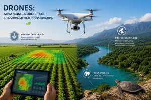
Precision agriculture is about using information to manage crops and resources more efficiently.
Drones can contribute to this process by collecting aerial imagery and other information from different parts of a field.
Instead of treating every acre exactly the same, farmers can potentially use detailed observations to better understand variations across their property.
Combined with other agricultural technology, drone information can help support decisions involving crop health, irrigation, field conditions, and resource management.
As drone sensors and analytical software become more sophisticated, this type of precision farming could become increasingly powerful.
Water is one of agriculture’s most important resources.
Problems with irrigation can affect crops while wasting water and increasing costs. Aerial views can help reveal patterns that may indicate areas receiving too much or too little water.
Drones can also help inspect irrigation infrastructure across larger properties without requiring someone to physically walk every section.
That doesn’t mean a drone can diagnose every irrigation problem, but it can help identify areas that deserve closer examination.
Severe weather can quickly affect large agricultural areas.
After strong winds, hail, flooding, or other damaging weather, farmers may need to determine which parts of a property have been affected.
Drones can provide an aerial overview that helps document visible damage and identify areas requiring additional inspection.
The ability to quickly survey a large area is one of the reasons drones can be valuable whenever conditions on the ground change rapidly.
This same advantage is also useful during natural disasters and other emergencies. Learn more in our article about Drones in Emergency Response and Public Safety.
Agriculture isn’t the only field benefiting from aerial technology.
Conservation professionals and researchers can use drones to observe landscapes, habitats, vegetation, coastlines, forests, wetlands, and other environments from above.
Traditional environmental surveys can require significant time and may involve accessing difficult terrain.
A drone can provide another way to collect visual information while reducing the need for people to physically enter every location being studied.
Monitoring wildlife can be challenging, particularly across large or remote areas.
Drones may help researchers survey habitats and observe environmental conditions from above.
Depending on the situation, aerial imagery can provide useful information about where animals live, how habitats are changing, and which areas may require additional study.
Responsible operation is especially important around wildlife. Drones should be flown in accordance with applicable rules and in ways that avoid unnecessarily disturbing animals or sensitive environments.
Forests cover enormous areas, making comprehensive ground-level observation difficult.
Drone imagery can help researchers and land managers examine sections of forests, observe vegetation, document visible changes, and identify areas that may deserve closer investigation.
Similar technology can be used around wetlands, waterways, coastlines, and other natural environments.
Repeated aerial surveys can be particularly useful because they allow researchers to compare conditions over time.
One of the most powerful uses of drones is documenting change.
Aerial photographs and mapping technology can provide a visual record of how an area looks at a particular point in time.
Researchers can later compare those observations with newer imagery to study changes in vegetation, erosion, water levels, storm damage, land use, and other environmental conditions.
As drone cameras, positioning systems, and mapping software improve, these comparisons can become increasingly detailed.
Agricultural and conservation applications don’t eliminate the need for responsible drone operation.
Pilots still need to consider airspace restrictions, people and property, wildlife, weather conditions, privacy, and applicable regulations.
Automated flight technology, GPS, obstacle detection, and other features can assist pilots, but they don’t replace responsible decision-making.
Before flying, operators should understand the current rules that apply to their location and intended use.
For a deeper look at responsible flying, read Drone Safety, Privacy and Regulations: What You Need to Know.
Today’s drones can include impressive technology such as high-resolution cameras, GPS positioning, optical-flow hovering, obstacle detection, automated flight features, and return-to-home functions.
More specialized agricultural and professional drones can use additional sensors and equipment designed for specific applications.
Consumer drones aren’t substitutes for specialized agricultural or conservation equipment, but many use similar underlying technologies.
If you’re interested in experiencing modern drone technology yourself, browse the latest drones at Today’s Gadget Needs and compare the cameras and flight features available.
Drone technology is still evolving.
Improvements in artificial intelligence, cameras, sensors, battery life, navigation, automation, and data analysis could make drones even more valuable for agriculture and environmental research.
Future systems could become better at identifying changes in crops, analyzing large areas, creating detailed maps, monitoring environmental conditions, and providing useful information with less manual processing.
For agriculture, that could mean more precise information for managing crops and resources.
For conservation, it could mean better tools for understanding and protecting natural environments.
The real value of drone technology isn’t simply that drones can fly. It’s the new perspective they can provide.
For farmers, that perspective can help reveal what’s happening across large fields.
For conservation professionals and researchers, it can provide another way to study landscapes, habitats, and environmental changes.
As drone technology continues to improve, agriculture and conservation are two areas where the view from above could make an increasingly meaningful difference.
Want to experience today’s drone technology for yourself? Explore drones at Today’s Gadget Needs and discover the latest options for taking your view to the sky.
Want to see drone technology in action? Check out this short video and discover how it’s shaping the future of farming.
